Insight
Storm Eunice: Ample warning has prepared the UK for the storm of the decade

ITV News Presenter Becky Mantin reports on the gusts recorded today and the forecast to come over the next few days
One of the most reassuring things that any weather person can ever hear is; "everything is going to plan..."
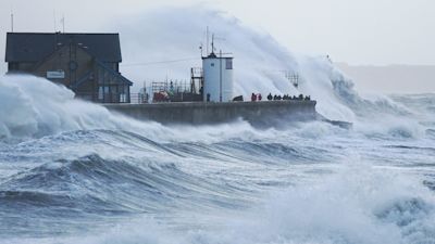
Storm Eunice has brought widespread disruption, damage and, as the Met Office warns, 'danger to life'.
We've had record breaking winds (122mph gust at The Needles, Isle Of Wight), and rare red weather warnings - so rare in fact that this is the first time that a red weather warning has ever been issued in London.
High tides, trees on tracks, the army on standby and the ubiquitous shots of reporters getting drenched by rogue waves, widespread power outages, damage to buildings (including the O2 even!) and still hours before the clean up can begin. But what we haven't had - and what is, as we all know, the most devastating and damaging of all - is lack of warning.
The Met Office, ITV's data supplier, has been ahead of this storm for several days and, yes, 'everything has gone to plan'. This doesn't lessen the damage and the danger of course, but at least with ample, detailed warning, this can be mitigated to some extent; people staying at home, securing all they can, hunkering down...
There's no doubt that Storm Eunice has been up there with some of the most powerful storms that the UK has ever seen with winds gusting to over 80mph inland with mean speeds for some of nearly 50mph - these areas usually far more protected from the worst of these events.
That 122mph gust is actually stronger than any gust recorded in the Great Storm of 1987. It helps, of course, that Eunice has hit in February rather than, as then, October when many of the trees still had their leaves. Eunice has yet to reveal its true toll, of course, but there is no doubt that forewarned really has meant forearmed.
And we had better get used to the wild and windy weather - although, to be clear, nothing like as wild and windy as we've seen today.
Over the next few days, under continued batterings from Atlantic low pressure systems, the weather will continue to be windy and disruptive with spells of rain at times, snow across more northern areas and ice a problem for much of Scotland.
Weather warnings are in force for various combinations of wind, rain and ice for the next three days at least with the slim potential for Sunday's low pressure system to be a named storm (Franklin).
Stay up to date with the latest weather forecasts for the very latest where you are.