Explainer
Sting jet, weather bomb and jet stream - key terms to know as Storm Eunice hits

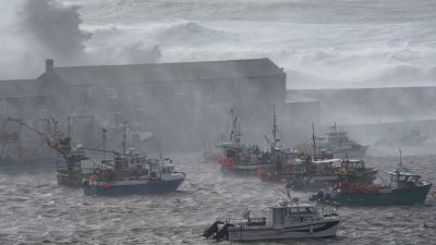
Winds of up to 90mph are battering the UK as Storm Eunice hits, with the south of England and Wales particularly badly hit.
Wind gusts in the most exposed coastal areas could exceed 90mph, the Met Office said, while an amber warning for gusts up to 80mph covers the whole of England from 5am to 9pm.
With a lot of technical weather terms being mentioned in relation to the storm, here are the meanings of a few key ones you may need to know:
Sting jet
A sting jet is a concentrated area of intense wind that can form inside storms.
They usually last three or four hours and are relatively narrow - typically around 30 miles across.
The Met office has warned this rare weather phenomenon could form later on Friday when the full force of Storm Eunice hits.
As Storm Eunice is expected to bring extremely high gusts, sting jets can create significant damage to property and can be a risk to life- especially in the case of falling debris.
Sting jets were only officially recognised after the Great Storm of 1987 (which impacted the UK)- where wind speeds reached 115mph - and have only happened a handful of times since.
Th Great Storm claimed 18 lives and caused an estimated 15 million trees to fall.
Jet streams can be spotted by satellites when the end of the cold conveyor belt - a strong stream of cold air- forms a hook-shaped cloud that resembles the sting of a scorpion's tail.
The Met Office said: “The cold conveyor brings its cold air from higher in the atmosphere and from being in a cold air mass. Sometimes it has help from rain and snow as they fall into it and evaporate. “This change from liquid to gas requires heat, which is removed from the conveyor, cooling it further. Now we have even colder air falling along the conveyor, speeding up as it does so, like a rollercoaster taking the first drop. “As this wind reaches the surface it can often produce much stronger gusts than would otherwise be made by the storm. However, the cold conveyor catches up with itself after a few hours and consumes the sting jet, keeping the length of time and area of potential damage quite small.”
What is Explosive Cyclogenesis - or a 'weather bomb'? A 'weather bomb' is jargon (often used in the US) for Explosive Cyclogenesis. It's when a low pressure system/storm forms rapidly - and this is how Storm Eunice is developing.
The storm has unusually formed over warmer waters of the Azores and is taking a particularly rapid track to the UK. With no time to release its energy before reaching us, it'll bring winds near 90mph as it reaches our shores and makes landfall.
What is a jet stream?
A jet stream is a narrow zone of high-speed winds, which can extend several thousand miles long.
They are usually found some 30,000 feet up in the atmosphere and are what help meteorologists forecast the weather as the winds influence global weather patterns.
Jet streams are produced through significant temperature differences between the poles and the tropics and can reach speeds of up to 250mph.
What is a 'red' weather warning?
A red warning is the Met Office's most severe weather warning, meaning dangerous weather is expected and you should take action to keep yourself and others safe.
It is very likely there will be a risk to life, with substantial disruption to travel, energy supplies and possibly widespread damage to property and infrastructure.
You should avoid travelling, where possible, and follow the advice of the emergency services and local authorities.
The last time we had a red warning for winds in Wales was on February 12, 2014 - that's before we even started naming storms.
This is pretty rare. And coupled with those high spring tides, it's going to make for some pretty treacherous conditions.
Red warnings are seen once or twice a year and are usually concentrated in quite small areas.