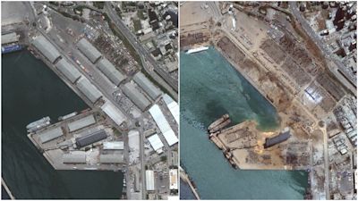
Beirut explosion: Before and after satellite images show extent of devastation

Satellite images show the extent of the devastation caused by the massive explosion at Beirut's port on Tuesday.
The after photo shows a huge crater where a warehouse once stood.
Across the harbour lies an overturned cruise liner, the Orient Queen, tipped on its side by the force of the explosion. Two members of the ship's crew are known to have died in the explosion, which British engineering experts say is “unquestionably” one of the largest non-nuclear blasts in history.A team from the University of Sheffield has calculated the strength of the blast based on the videos and photographs which have emerged since Tuesday’s catastrophe.
They believe the explosion was the equivalent of 1,000 to 1,500 tonnes of TNT – a blast intensity which would support the belief that it was caused by a fire leading to the detonation of 2,750 tonnes of ammonium nitrate fertiliser.
This is about a tenth of the intensity of the Hiroshima nuclear bomb but far bigger than any blast from a conventional weapon.
Overhead images show warehouses razed to the ground and scorched ground where buildings, seen in pictures taken in the months before the blast, once stood.
At least 135 people were killed in the blast and over 5,000 injured. The search for survivors amid the rubble continues with dozens of people still missing.
Buildings up to 15 miles away were damaged by the explosion, which experts say was felt as far away as Cyprus, more than 180 miles across the Mediterranean.
The Lebanese government has declared a two-week state of emergency, effectively giving the military full powers during this time, as speculation mounts that negligence might be to blame.
The damage caused by the blast is estimated to cost billions to a country already on its knees economically.