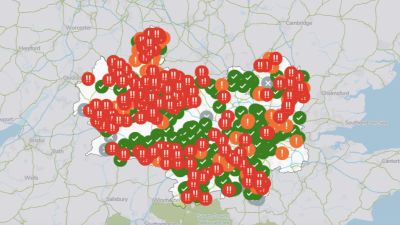
New sewage map reveals continuous discharges by Thames Water across London and Thames Valley

An interactive map released by Thames Water has revealed where the company is making continuous sewage discharges across London and the Thames Valley.
The interactive map on its website shows the locations of affected waterways and the time that sewage discharge began.
Looking at the map, Oxfordshire appears to be one of the areas most affected.
In Bletchingdon, which feeds into Bletchingdon Stream, the storm overflow is currently discharging.
Thames Water says this means there could be sewage in this section of the watercourse.
Other areas where storm overflows are currently discharging include:
Islip which feeds into River Ray
Wheatley which feeds into Wheatley Ditch
Bicester which feeds into Langford Brook
Water companies are allowed to release untreated sewage into rivers in exceptional circumstances, for example, during heavy rainfall.
Thames Water says it is committed to protecting and enhancing rivers and the communities that love them.
The firm added it wants to make discharges of diluted sewage unnecessary as quickly as possible.
It was one of the biggest news stories of our time - and it's still not over. So what did Boris Johnson know about Downing Street’s notorious parties?
With fresh revelations from our Number 10 sources, in their own words, listen to the inside story...