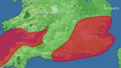
Extreme weather forecast for London as capital gets first red weather warning from Storm Eunice

By Sally Williams, ITV London Weather Presenter
One of the worst storms we’ve see for years is heading towards the capital this morning.
A very rare red warning is in place meaning there is a danger to life due to strong winds.
The warning is in place after 10am until 3pm. After rain overnight and in this morning winds will continue to strengthen.
Gusts of 60-70mph, possibly stronger, are expected to reach the London between mid morning and mid afternoon.
Storm Eunice is a deep area of low pressure reaching the south west of the UK first before heading east and north.
It is rare to see winds this strong inland over densely populated areas.
The warning is for the risk of significant disruption including falling trees and branches, damage to power lines, buildings and roofs.
Where there is flying debris it could be very dangerous. Scaffolding for example across the capital could be a threat.
Expect disruption to travel, cancelled trains and flights, as well as bridge and road closures. Mobile phone services could also be affected.
Met Office Chief Meteorologist Paul Gundersen said: "After the impacts from Storm Dudley for many on Wednesday, Storm Eunice will bring damaging gusts in what could be one of the most impactful storms to affect southern and central parts of the UK for a few years.
"The red warning areas indicate a significant danger to life as extremely strong winds provide the potential for damage to structures and flying debris."The amber warning previously issued over much of England remains in place until 9pm.