Lenticular clouds. What are they and how are they formed?

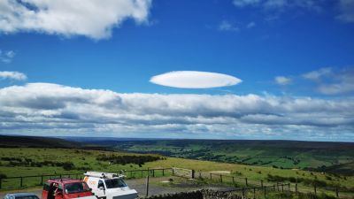
This "UFO" cloud was spotted yesterday (July 28th) over the North York Moors. It is a lenticular cloud but what do we know about them?
These lens-shaped orographic wave clouds form when the air is stable and winds blow across hills and mountains from the same or similar direction at different heights through the troposphere
These strange, unnatural looking clouds sometimes form downwind of hills or mountains. They are quite unusual in the British Isles but do occasionally occur. They look a lot like the traditional shape of flying saucers in science fiction, and real lenticular clouds are believed to be one of the most common explanations for UFO sightings across the world.
How do lenticular clouds form?When air blows across a mountain range, in certain circumstances, it can set up a train of large standing waves in the air downstream, rather like ripples forming in a river when water flows over an obstruction. If there is enough moisture in the air, the rising motion of the wave will cause water vapour to condense, forming the unique appearance of lenticular clouds.
What weather is associated with lenticular clouds?Lenticular clouds are a visible sign of mountain waves in the air. However, these waves can be present beyond the clouds, and may exist even when no clouds are formed.
On the ground, they can result in very strong gusty winds in one place, with still air only a few hundred metres away. Pilots of powered aircraft tend to avoid flying near lenticular clouds because of the turbulence that accompany them. Skilled (and brave) glider pilots, on the other hand, like them, because they can tell from the shape of the clouds where the air will be rising.