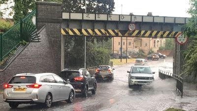
Torrential downpours cause flash floods as weather warning for thunderstorms upgraded to amber

A spell of hot weather has been washed away, with thunder, lightning and sudden downpours causing flooding in parts of the UK - and delayed Manchester City's victory parade.
An amber thunderstorm warning was issued by the Met Office as parts of the UK were battered by heavy rain, lightning, hail and strong winds.
In the worst hit areas, close to 30mm of rain fell in an hour, causing some localised flooding.
But forecasters have said the worst of the weather is over.
Manchester City's parade following their Champions League win on Saturday was delayed by torrential downpours and lightning.
The London Fire Brigade was urging people not to drive through floodwater after parts of the North Circular were completely submerged.
The service also confirmed it had been called out to several floods across the capital.
People watching the Rothesay Open 2023 at the Nottingham Tennis Centre had to leave the stands and take shelter as the games were delayed due to the heavy rain.
The heavy thunderstorms caused drastic drops in temperature, ITV News weatherman Chris Page said.He tweeted: "In the last hour, the temperature at East Mids Airport has dropped from 28C to 19C - something more typical for the time of year."
The warning, which covered parts of Leicester, Birmingham, Worcester, Gloucester and Oxford, was in place until 7pm on Monday.
Met Office forecaster and meteorologist Simon Partridge said the "worst of the thunderstorms is now leaving" and drier weather was expected going into the latter parts of the week.
He said: “We do, already, have some thunderstorm warnings out for tomorrow. These are looking like they’re going to be down a notch or two compared to what we’ve seen today.
“We’ve got high pressure starting to rebuild over the course of the day and when you get high pressure that’s what gives us lots of dry, settled weather, like what we’ve had over the last couple of weeks.
“That’s becoming more established tomorrow and through the week so we will see a lot of the country tomorrow be dry with sunny spells."
There are two yellow thunderstorm warnings tomorrow, covering parts of western Scotland and Northern Ireland from midday to 9pm.
The Environment Agency has also issued 14 flood alerts across the Midlands, saying heavy, thundery showers could produce large amounts of surface water.
Want a quick and expert briefing on the biggest news stories? Listen to our latest podcasts to find out What You Need To Know...