Where in the UK is Storm Dudley hitting and what weather warnings are in place?

The UK is being hit by two storms across three days this week as forecasters warn winds of up to 90mph winds could pose a danger to life.
Two low pressure systems bringing spells of very strong winds and potentially snow between Wednesday and Friday have been named as Dudley and Eunice.
Here we look at where they'll hit and what impact they might have.
When is Storm Dudley due?
The storm hit on Wednesday and is anticipated to carry on through to Thursday morning.
Which places could be affected?
An amber weather warning is in place for parts of Northern Ireland, northern England and Scotland on Wednesday and Thursday.
The Met Office warning means places could see “very strong and disruptive” winds with potential to cause widespread chaos, including a “good chance” of power cuts and disruption to transport services.
This system has also brought some heavy rain and there is a potential for some significant snowfall over hills in the Midlands and further north.
Met Office forecaster Greg Dewhurst said: “We’ve seen Storm Dudley move in over the course of today with strong winds and heavy rain across northern parts of the country. “This is a complete contrast to areas in the south which have been rather mild and calm for the most part, the temperature even reaching 17°C in some areas. “Exposed areas in Scotland, Northern Ireland, parts of Wales and northern England have seen wind speeds largely between 60 and 70mph but the worst affected areas have reached and even surpassed 80mph this afternoon. “In terms of rainfall the highest we’ve seen in the past 24 hours is 36.8mm in Low Laithes in west Yorkshire, which is a good amount for the time period."
How strong is Dudley?
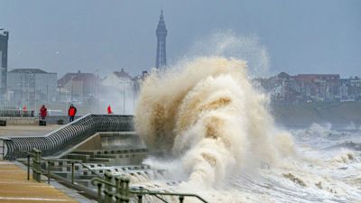
As of the early evening, Capel Curig in Wales had experienced gusts of up to 81mph. Emley Moore in Yorkshire saw 74mph winds, while Drumalbin in Scotland was hit by 71mph gales. Social media users shared images and videos of fallen trees, large waves smashing coastal areas, howling winds and rain sweeping through quiet roads and dark and gloomy skies, with some facing delays on public transport.
It is anticipated that the winds are expected to ease through Thursday afternoon and evening.
How will people be impacted?
The Met Office has issued an Amber and Yellow warning, which means:
Road, rail, air and ferry services may be affected, and some roads and bridges are likely to close, leading to longer journey times and cancellations.
Probably some fallen trees and damage to buildings, such as tiles blown from roofs
There is a good chance that power cuts may occur, with the potential to affect other services, such as mobile phone coverage
Injuries and danger to life is likely from large waves and beach material being thrown onto coastal roads, sea fronts and properties
Motorists have been warned to consider whether journeys later this week are absolutely necessary.
National Highways head of road safety Jeremy Phillips said: "We’re encouraging drivers to check the latest weather and travel conditions before setting off on journeys and consider if their journey is necessary and can be delayed until conditions improve.
"If you do intend to travel, then plan your journey and take extra care, allowing more time for your journey."
Mr Phillips added: "In high winds, there’s a particular risk to lorries, caravans and motorbikes so we’d advise drivers of these vehicles to slow down.
"Drivers of other vehicles should be aware of sudden gusts of wind which can affect handling and braking, and give high-sided vehicles, caravans, and motorbikes plenty of space. In the event of persistent high winds we may need to close bridges to traffic for a period, so please be alert for warnings of closures and follow signed diversion routes."
ScotRail wound down almost all services from 4pm amid fears of falling trees and blowing debris as wind speeds are expected to reach more than 80mph.
Ferries in Scotland have also been severely disrupted, with 20 of the 29 routes experiencing cancellations.
Electricity supply firms have also issued warnings following the widespread outages in northern England and Scotland which followed storms earlier this year.
How did Dudley get its name?
The Met Office takes name suggestions and creates an alphabetical list of storm names which are attributed to them once they are likely to happen.
What is the next storm?
As Storm Dudley winds down, another will arrive, forecasters have named it Storm Eunice, and it's predicted to hit at the end of the week bringing heavy rain and possible snowfalls on high ground from the Midlands northwards.
The Met Office said that, where snow does fall, the high winds are likely to create blizzard conditions.
Storm Eunice will track across central areas of the UK on Friday with further very strong winds expected, with 60mph–70mph gusts possible inland, perhaps even stronger in some places.