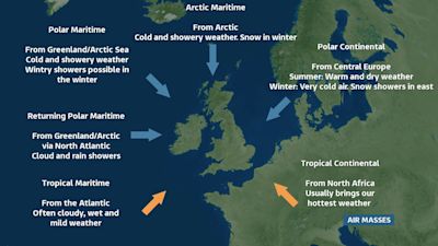
Where does our weather come from?

When it comes to weather forecasting, wind direction is such an important thing to consider. It's also one of the oldest forms of forecasting because of what a certain direction will typically bring. Southerly winds drag up warm air from Africa or Spain and a northerly will make it feel cold, and perhaps bring snow.
The different directions are lumped together in a term called 'air masses' and basically mean just that - what chunk of air is over the top of us and where did it come from?
The two main influences of our wind are whether it flows over the land or the sea. This gives it the term 'continental' or 'maritime' respectively. The direction that the air has travelled from then gives it either a 'tropical' (from a warmer part of the globe), 'polar' (from a colder place) or 'arctic' (from the north pole) descriptive term.
Our prevailing, or most common wind direction is a southwesterly, which is a Tropical Maritime air mass - one that flows over the sea and comes in from the southwest Atlantic, dragging in mild air that's usually cloudy and wet. Plenty of our weather systems contain this type of air mass.
Polar Maritime air is a colder air mass that moves over the sea, either straight from the northwest or a Returning Polar Maritime that curls back around the north Atlantic, picks up even more moisture but also warms up a bit. This brings sunshine and showers, and often the clearest visibility giving some of the best views, and of course rainbows!
The coldest wind is a northerly, or Arctic Maritime. This blows from the north pole over the Norwegian and North Sea bringing some of the lowest temperatures and snowiest conditions, especially in winter.
Polar Continental air is one that originates from central Europe and brings different weather depending on the time of year. In summer the huge land mass to the east of us heats up and a northeasterly brings us plenty of warm and dry weather. However, in winter the opposite happens and we end up with biting cold easterly winds that can bring snow showers. The Beast from the East was a classic winter time Polar Continental air mass.
Finally, our warmest air mass is one that comes in from the south and southeast and is called Tropical Continental. This air originates from north Africa and the Mediterranean bringing plenty of hot dry weather, especially in summer.
So, six main types of air mass that can be used to describe what sort of weather we'll see and gives us clues as to where all that weather is coming from.